Archives
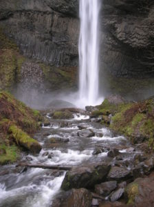
Quick Facts: Location: Columbia River Gorge National Scenic Area Land Agency: Oregon State Parks Roundtrip: 2.3 miles Elevation Gain: 650 feet Green Trails Map: Columbia River Gorge- West no. 428S Contact: Guy Talbot State Park Access: From Portland follow I-84 east to Exit 28. Then follow the Historic Columbia Highway…
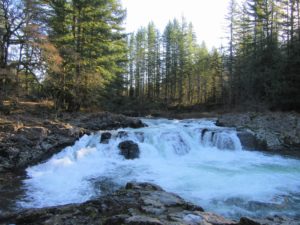
Small falls roar come winter Quick Facts: Location: East Fork Lewis River, Clark County WA Land Agency: Clark County Parks Round Trip: 1.0 mile Elevation Gain: 60 feet Contact: Clark County Parks Detailed Information: Urban Trails Vancouver WA (Mountaineers Books) Notes: Dogs permitted on leash. Park is open 7 am…

Quick Facts: Location: Olympic Coast Land Agency: National Park Service Roundtrip: To Ruby Beach: 0.5 mile; To Hoh River: 6.0 miles Elevation Gain: 80 feet Green Trails Map: Olympic Coast 99S Notes: Dogs permitted but must be on a leash. Access: From Forks, head south on US 101 for 27…
Quick Facts: Location: Snoqualmie Valley near North Bend Land Agency: Washington State Parks Roundtrip: 4.2 miles Elevation Gain: 900 feet Green Trails Map: Rattlesnake Mountain Upper Snoqualmie Valley 205S Access: From Seattle take I-90 east to exit 32 in North Bend turning right (south) onto 436th Ave SE which soon becomes Cedar…
Explore a former farm in the heart of Camano Island Quick Facts: Location: Camano Island Land Agency: Island County Parks Round Trip: 1.5 miles of trails Elevation Gain: up to 200 feet Contact: Island County Parks Detailed Information: Urban Trails Everett (Mountaineers Books) Notes: Dogs permitted on leash. No map…
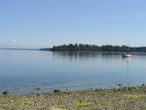
Madronas, big maples and sweeping views of Mount Rainier Quick Facts: Location: Key Peninsula Land Agency: Washington State Parks Round Trip: 2.5 miles of trails Elevation Gain: 200 feet Contact: Penrose Point State Park Detailed Information: Urban Trails Kitsap (Mountaineers Books) Notes: Discover Pass required, Dogs permitted on leash Access:…
Quick Facts: Location: City of Monroe Land Agency: Monroe Parks and Recreation Department Roundtrip: 1.6 miles Elevation Gain: None Notes: Dogs must be on leash. Access: From Everett follow US 2 east towards Monroe. Turn right at first traffic light onto Fryelands Boulevard. Continue for .7 mile to junction with…

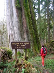
Quick Facts: Location: Capitol State Forest Land Agency: Washington Department of Natural Resources (DNR) Roundtrip: 1.5 miles Elevation Gain: minimal Contact: Washington Department of Natural Resources (DNR); South Puget Sound Region Office Notes: Discover Pass required; dogs permitted on leash Access: From Exit 104 on I-5 in Olympia, head west on…
Quick Facts: Location: Mountain Loop Highway Land Agency: Mount Baker-Snoqualmie National Forest Roundtrip: 1.5 mile Elevation gain: 200 feet Green Trails Map: Mountain Loop Highway 111SX Contact: Darrington Ranger District: Mount Baker Snoqualmie National Forest Notes: No passes needed Access: From Darrington, follow Mountain Loop Highway for 11.3 miles to…

Quick Facts: Location: Western Lewis County Land Agency: Washington State Parks Roundtrip: 10.0 miles Elevation Gain: 100 feet Access: From Chehalis (exit 77 on I-5) follow SR 6 west for 23 miles to the town of Pe Ell. At blinking red light turn left onto 6th Ave and proceed 0.1…