Archives
Quick Facts: Location: Bellingham Distance: more than 9.0 miles of trails Elevation Gain: up to 600 feet Contact: City of Bellingham Park Map: Square One Maps Chuckanut Recreation Area Notes: on-leash and off-leash trails Trailhead directions: From Bellingham follow I-5 south to Fairhaven Exit 252. Then continue south on Samish…
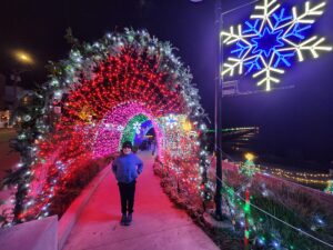
Quick Facts: Location: White Rock BC Distance: 4.4 km (2.7 miles) round trip Elevation Gain: minimal Contact: City of White Rock Recreation and Culture Recommended Guidebook: Urban Trails Vancouver, BC (Mountaineers Books) Notes: Bright Walk runs from late November until mid-January. Check city website for exact dates. Promenade open year…
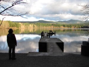
Quick Facts: Location: Vashon Island Land Agency: King County Parks Round Trip: More than 10 miles of trails Elevation Gain: up to 450 feet Contact: King County Parks Detailed Information: Urban Trails Seattle (Mountaineers Books) Notes: Dogs allowed on leash Access: From Seattle take Washington State Ferry from Fauntleroy (West…
Quick Facts: Location: Olympia, Washington Land Agency: City of Olympia Parks and Recreation Roundtrip: 2.5 miles Elevation Gain: 300 feet Notes: Dogs must be on a leash. Access: From Lacey, follow I-5 south to Olympia taking Exit 105B to Plum Street. From Tumwater, follow I-5 north to Olympia taking Exit…

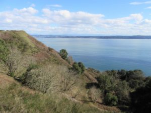
Bountiful birds and beautiful views of Mount Baker Quick Facts: Location: Surrey and Delta, BC Distance: 16.9 km (10.5 miles) one way Elevation Gain: minimal Contact: Metro Vancouver Regional Parks, Surrey Parks and Recreation Recommended Guidebook: Urban Trails Vancouver, BC (Mountaineers Books) Notes: Dogs permitted on leash; but dogs not…
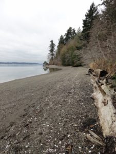
Quick Facts: Location: Camano Island Land Agency: Washington State Parks Roundtrip: 2.2 miles Elevation Gain: 125 feet Contact: Cama Beach State Park Notes: Discover Pass required; Dogs must be leashed Recommended Guidebook: Urban Trails Everett (Mountaineers Books) Access: From Exit 212 on I-5, travel west on SR 532 to Camano Island to…
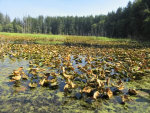
A slough of surprises await just minutes from downtown Everett Quick Facts: Location: City of Everett Land Agency: Everett Parks and Recreation Department Roundtrip: 4.0 miles Elevation Gain: None Access: From Everett, take Exit 195 off of I-5 turning left onto East Grand Ave. In 0.5 mile bear right onto East…
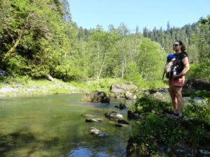
A near yet remote canyon housing big trees and a wild stretch of river Quick Facts: Location: Sultan Basin Land Agency: Snohomish County Public Utility District Roundtrip: 4.4 miles Elevation Gain: 850 feet Green Trails Map: Mountain Loop Highway 111SX Access: From Everett follow US 2 east to Sultan. At a traffic light just past…

Quick Facts Location: Mountain Loop Highway near Granite Falls Land Agency: Mount Baker-Snoqualmie National Forest Roundtrip: 5.4 miles Elevation Gain: 1,350 feet Green Trails Map: Mountain Loop Highway 111SX Notes: NW Forest Pass required; dogs permitted on leash; trail can get busy, practice Leave No Trace ethics and consider visiting…
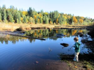
Extensive peat bog teem with flora and fauna Quick Facts: Location: Snoqualmie Valley Distance: 3.0 miles of trails Elevation Gain: minimal Contact: King County Parks Recommended Guidebook: Urban Trails Eastside (Mountaineers Books) Notes: dogs welcome on leash Trailhead directions: Use your phone App to map to Moss Lake Natural Area…