Archives

Quick Facts Location: Mountain Loop Highway, Darrington Land Agency: Mount Baker-Snoqualmie National Forest Roundtrip: 2.0 miles Elevation Gain: 300 feet Green Trails Map: Silverton, WA-No. 110 Access: From Arlington follow SR 530 east for 28 miles to Darrington. At a three-way stop, turn right onto the Mountain Loop Highway and…
Quick Facts Location: Glacier Peak Wilderness Land Agency: Mount Baker-Snoqualmie National Forest Roundtrip: 26.6 miles Elevation Gain: 5,100 feet Green Trails Map: Holden, WA- No. 113 Contact: Darrington Ranger District: Mount Baker Snoqualmie National Forest (360) 436-1155; www.fs.fed.us/r6/mbs Notes: Northwest Forest Pass required. Access: From Everett, head 85 miles east…
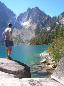
Quick Facts Location: Alpine Lakes Wilderness, Icicle River Valley Land Agency: National Forest Service Roundtrip: 8.4 miles Elevation Gain: 2,200 feet Green Trails Map: The Enchantments- No. 209S Contact: Wenatchee River Ranger District (Leavenworth): Okanogan-Wenatchee National Forest; www.fs.fed.us/r6/wenatchee Notes: Northwest Forest Pass required; Dogs prohibited; Special Enchantment Permit required for…
Quick Facts Location: Mountlake Terrace, Edmonds and Lynnwood Land Agency: Snohomish County Parks Roundtrip: 5.0 miles Elevation Gain: Minimal Contact: Snohomish County Parks; www1.co.snohomish.wa.us/Departments/Parks Notes: Dogs permitted on leash. Access: From I-5 take exit 178. Head west on 236th Street SW which eventually becomes Lakeview Drive. After about one mile,…
Quick Facts Location: Stillaguamish River Valley, Arlington Land Agency: Snohomish County Parks Roundtrip: 1.0 miles Elevation Gain: none Contact: Snohomish County Parks; www1.co.snohomish.wa.us/Departments/Parks/ Notes: Dogs must be on leash. Access: From Exit 208 on I-5, head east on SR 530 for 4.0 miles to Arlington. Continue east on SR 530…
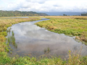
Quick Facts Location: Columbia River Gorge National Scenic Area Land Agency: US Fish and Wildlife Roundtrip: 2.8 miles Elevation Gain: none Contact: www.fws.gov/ridgefieldrefuges/steigerwaldlake Green Trails Map: Columbia River Gorge West No. 428S Notes: Dogs prohibited; section of trail closed from Oct 1—Apr 30 for wildlife protection. Access: From Vancouver head…

Quick Facts Location: Lake Crescent, Olympic National Park Land Agency: National Park Service Roundtrip: 8.0 miles Elevation Gain: 250 feet Contact: Olympic National Park; www.nps.gov/olym Green Trails Map: Lake Crescent, No. 101 Notes: Dogs are prohibited. Access: From Port Angeles, follow US 101 west for 17 miles turning right onto…
Quick Facts Location: Northern Snohomish County, near Stanwood Land Agency: Northwest Organization for Animal Help (N.O.A.H.) Roundtrip: 0.5 mile Elevation Gain: 25 feet Contact: www.thenoahcenter.org Notes: Hiking with dogs encouraged but they must be leashed. Access: From Everett, head north on I-5 to Exit 215. Head east on 300th Street…
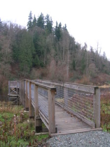
Quick Facts Location: Northern Snohomish County, near Stanwood Land Agency: Stillaguamish Tribe of Indians Roundtrip: 1.0 mile Elevation Gain: 50 feet Contact: www.stillaguamish.nsn.us Notes: Dogs must be leashed. Access: From Everett, head north on I-5 to Exit 210. Turn left heading west on 236th Street NW. Within a .25 mile…
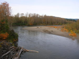
Quick Facts Location: North Fork Skykomish River Valley Land Agency: Mount Baker-Snoqualmie National Forest Roundtrip: 12.0 miles Elevation Gain: 1,200 feet Green Trails Map: Monte Cristo- No. 143, Benchmark Mtn- No. 144 Contact: Skykomish Ranger District: Mount Baker-Snoqualmie National Forest; (360) 677-2414; www.fs.fed.us/r6/mbs Special Note: Northwest Trail Pass required. Access:…