Archives
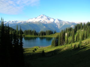
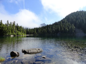
Quick Facts: Location: Glacier Peak Wilderness Land Agency: Mount Baker-Snoqualmie National Forest Roundtrip: 33.0 miles Elevation Gain: 4,700 feet Green Trails Map: Mountain Loop Highway 111SX Contact: Darrington Ranger District: Mount Baker Snoqualmie National Forest Notes: NW Forest or Interagency Pass required; No camping within ¼ mile of Image Lake—use established campsites; no…
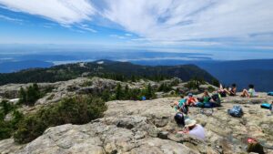
Quick Facts: Location: North Shore Mountains, North Vancouver, BC Distance: 8.4 km (5.2 miles) roundtrip Elevation Gain: 540 m (1772 feet) Contact: Mount Seymour Provincial Park Recommended Guidebook: Urban Trails Vancouver, BC (Mountaineers Books) Notes: Trail to Mount Seymour is snow free from July through October. Other trails in park…
Location: Kettle River Range Land Agency: National Forest Service Roundtrip: 6.0 miles Elevation gain: 2,000 feet Contact: Colville National Forest Access: From Republic, head east on SR 20 for 21 miles turning left onto FR 2030 (Albion Hill Road). From Kettle Falls, head west on SR 20 for 22 miles, turning right…
Quick Facts: Location: Nisqually River Valley Land Agency: National Forest Service Round Trip: 4.0 miles Elevation Gain: 1450 feet Contact: Cowlitz Valley Ranger Station (Randle), Gifford Pinchot National Forest Green Trails Maps: Randle, WA no. 301 Notes: Road to trailhead can be rough. Trail is open to motorcycles but sees little…
Quick Facts: Location: Skykomish Valley Land Agency: National Forest Service Round Trip: 10.0 miles Elevation Gain: 1350 feet Contact: Skykomish Ranger District, Mount Baker-Snoqualmie National Forest Green Trails Maps: Alpine Lakes West Stevens Pass No 176S Notes: Northwest Forest Pass or Interagency Pass required Access: Follow US 2 east to Skykomish. Then…
Quick Facts: Location: Wild Sky Wilderness near Skykomish River Valley Land Agency: National Forest Service Roundtrip: 3.0 miles Elevation Gain: 1,400 feet Access: From Everett head east on US 2 for 50 miles (just past Skykomish) turning left onto Beckler River Road (FR 65). Continue 12.6 miles to a five-way…
Quick Facts: Location: Ross Lake National Recreation Area, North Cascades Scenic Highway (SR20) Land Agency: National Park Service Roundtrip: 9.0 miles Elevation Gain: 2,350 feet Green Trails Map: North Cascades Ross Lake 16SX Special Note: Dogs must be leashed. Contact: North Cascades National Park Visitors Center Newhalem Recommended Guidebook: Day Hiking North Cascades…
Quick Facts: Location: Stevens Pass area Land Agency: Mount Baker-Snoqualmie National Forest Roundtrip: 11.0 miles Elevation Gain: 2,800 feet Contact: Skykomish Ranger District: Mount Baker-Snoqualmie National Forest Notes: Northwest Forest Pass required; Dogs permitted on leash; Wilderness rules apply Access: From Everett follow US 2 east to Skykomish. Continue 10 more…
Quick Facts:Location: Stevens Pass-Lake Wenatchee regionLand Agency: Okanogan-Wenatchee National ForestRound Trip: 10.0 milesElevation Gain: 2,600 feetContact: Wenatchee River Ranger District (Leavenworth): Okanogan-Wenatchee National Forest Green Trails Map: Wenatchee Lake- No. 145Recommended Guidebook: Day Hiking Central Cascades 2nd editionNotes: NW Forest Pass or Interagency Pass Required.Several miles of trails on this hike are…

Quick Facts: Location: North Cascades Highway Land Agency: Ross Lake National Recreation Area Roundtrip: 7.6 miles Elevation Gain: 1400 feet Contact: North Cascades National Park Detailed Information: Day Hiking North Cascades 2nd edition (Mountaineers Books) Notes: Dogs must be leashed. Access road gated at 4:15 pm during winter Access: From Marblemount follow SR…