Region
Central Cascades
Quick Facts: Location: Pacific Crest Trail near Stevens Pass Land Agency: Mount Baker-Snoqualmie National Forest Roundtrip: 6.5 miles Elevation gain: 1,550 feet Green Trails Map: Benchmark MT- No. 144 Contact: Skykomish Ranger District: Mount Baker -Snoqualmie National Forest Notes: Self-issued free wilderness permit available at trailhead. Wilderness regulations apply. No fires allowed near lake. Practice…
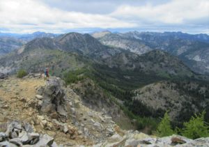
Quick Facts: Location: Pacific Crest Trail, Henry M Jackson Wilderness, Stevens Pass area Land Agency: Mount Baker-Snoqualmie National Forest Roundtrip: 16.4 miles Elevation gain: 3,400 feet Difficulty: difficult Green Trails Map: Benchmark MT- No. 144 Contact: Skykomish Ranger District: Mount Baker-Snoqualmie National Forest Access: From Everett, head east on US 2 to Stevens Pass. Continue…
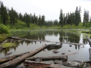
Quick Facts: Location: North Fork Skykomish River Valley Land Agency: Mount Baker-Snoqualmie National Forest Roundtrip: 17.4 miles Elevation Gain: 3,100 feet Contact: Skykomish Ranger District: Mount Baker-Snoqualmie National Forest Green Trails Map: Monte Cristo- No. 143, Benchmark Mtn- No. 144 Special Note: Northwest Forest Pass or Interagency Pass required; wilderness rules apply Access: From Everett…
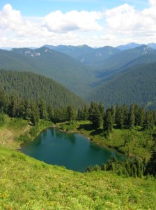
Quick Facts: Location: North Fork Skykomish River Valley Land Agency: Mount Baker-Snoqualmie National Forest Roundtrip: 14.2 miles High Point: 5,816 feet Elevation gain: 3,700 feet Green Trails Maps: Monte Cristo, WA-No. 143, Benchmark MT- No. 144 Contact: Skykomish Ranger District: Mount Baker-Snoqualmie National Forest Note: Northwest Forest or Interagency Pass Required Access: From Everett head…
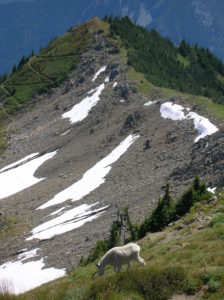
Location: Sawtooth Ridge near Lake Chelan Land Agency: Okanogan-Wenatchee National Forest Roundtrip: 5.0 miles Elevation gain: 1,550 feet Contact: Chelan Ranger District: Okanogan-Wenatchee National Forest Green Trails Map: Prince Creek- No. 115 Notes: access is via a long and bumpy gravel road. Four-wheel drive recommended. Good to Know: Exceptional wildflowers; exceptional views; backpacking options; exceptional…
Quick Facts: Location: Beckler River Valley Land Agency: Mount Baker-Snoqualmie National Forest Service Roundtrip: 13.0 miles Elevation Gain: 2,700 feet Green Trails Map: Benchmark Mtn- No. 144 Recommended Guidebook: Day Hiking Central Cascades Access: From Everett head east on US 2 for 50 miles to Skykomish turning left onto the Beckler River Road (FR 65). Continue north for 6.9 miles…
Location: Beckler River near Skykomish Land Agency: Mount Baker-Snoqualmie National Forest Roundtrip: 9.0 miles High Point: 5,540 feet Elevation gain: 2,650 feet Difficulty: difficult Green Trails Maps: Alpine Lakes West Stevens Pass No. 176S Contact: Skykomish Ranger District: Mount Baker-Snoqualmie National Forest Access: From Everett head east on US 2 for 50 miles turning left onto…
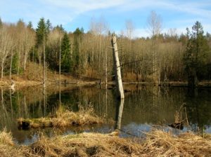
Location: Lord Hill Park near Snohomish Land Agency: Snohomish County Parks Roundtrip: 2.2 miles High Point: 650 feet Elevation gain: 200 feet Difficulty: easy Contact: Snohomish County Parks Notes: Dogs must be on leash; Map available online Access: From Everett, head east on US 2 for 8.0 miles and take 88th Street SE Exit. Turn right…
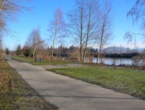
Quick Facts: Location: Lowell neighborhood, city of Everett Land Agency: Everett Parks and Recreation Contact: Everett Parks and Recreation Department Roundtrip: 4.0 miles Elevation Gain: None Access: From Exit 192 on I-5 in Everett head east on 41st Street. Turn right (south) onto 3rd Ave and proceed for 1.2 miles to four-way stop. Turn left onto…
Quick Facts: Location: Nason Ridge near Stevens Pass Land Agency: Okanogan-Wenatchee National Forest Roundtrip: 9.8 miles Elevation Gain: 3,250 feet Green Trails Map: Alpine Lakes Stevens Pass Map 176S Access: From Everett head east on US 2. Four miles past Stevens Pass turn left onto Smith Brook Road (FR 6700). Follow for 6.0 miles turning…