Region
North Cascades
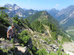
Quick Facts: Location: North Cascades, E.C. Manning Provincial Park Land Agency: BC Parks Roundtrip: 13.2 miles Elevation Gain: 3820 feet Contact: E.C. Manning Provincial Park Notes: Dogs permitted on leash. Practice Leave No Trace principles. Access: From Vancouver BC follow Trans-Canada Highway 1 east to Hope. Then continue east on BC 3 (Crowsnest Highway) for 37.5 miles and…
Quick Facts: Location: Mountain Loop Highway near Granite Falls Land Agency: Mount Baker-Snoqualmie National Forest Roundtrip: 8.6 miles High Point: 5,723 feet Elevation gain: 3,900 feet Difficulty: difficult Green Trails Map: Mountain Loop Highway No. 111SX Contact: Darrington Ranger District: Mount Baker Snoqualmie National Forest Notes: Northwest Forest Pass required Access: From Granite Falls follow…
Quick Facts: Location: Mount Baker Highway, North Cascades Land Agency: National Forest Service Roundtrip: 9.0 miles Elevation gain: 2500 feet Difficulty: moderate Green Trails Map: Mount Baker Wilderness 13S Contact: Mount Baker Ranger District: Mount Baker -Snoqualmie National Forest Access: From Bellingham follow SR 542 (Mount Baker Highway) east for 35 miles turning right onto…
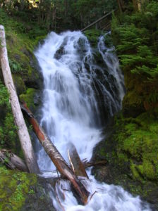
Quick Facts: Location: Mountain Loop Highway, near Granite Falls Land Agency: Mount Baker-Snoqualmie National Forest; Washington State Parks Roundtrip: 4.2 miles Elevation gain: 1,100 feet Green Trails Maps: Mountain Loop Highway 111SX Contact: Darrington Ranger District: Mount Baker-Snoqualmie National Forest Notes: access road is rough, high clearance vehicles recommended. Access: From Granite Falls follow the…
Quick Facts: Location: Mountain Loop Highway near Barlow Pass Land Agency: Mount Baker-Snoqualmie National Forest Roundtrip: 17.0 miles Elevation gain: 3,900 feet Green Trails Map: Mountain Loop Highway no. 111SX Contact: Darrington Ranger District: Mount Baker Snoqualmie National Forest Notes: Northwest Forest Pass or Interagency Pass required; A washout at the Twin Bridges requires…

Location: Mountain Loop Highway Land Agency: Mount Baker-Snoqualmie National Forest Roundtrip: 5.2 miles High Point: 4,650 feet Elevation gain: 1,900 feet Difficulty: challenging Green Trails Maps: Mountain Loop Highway No. 111SX Contact: Darrington Ranger District: Mount Baker Snoqualmie National Forest Access: Take Exit 208 off of I-5 following SR 530 east for 32 miles to Darrington.…
Quick Facts: Location: Mountain Loop Highway near Darrington Land Agency: Mount Baker-Snoqualmie National Forest Roundtrip: 7.0 miles Elevation Gain: 900 feet Green Trails Map: Mountain Loop Highway no.111SX Note: NW Forest Pass required Access: From Granite Falls follow the Mountain Loop Highway east for 31 miles to Barlow Pass and end of pavement. Continue for 3.5 miles turning…
Quick Facts: Location: Mountain Loop Highway near Granite Falls Land Agency: Mount Baker-Snoqualmie National Forest Roundtrip: 2.0 miles Elevation gain: 300 feet Difficulty: easy (with some rough footing) Green Trails Map: Mountain Loop Highway 111SX Contact: Darrington Ranger District: Mount Baker-Snoqualmie National Forest Access: From Granite Falls, follow the Mountain Loop Highway east to the Verlot…
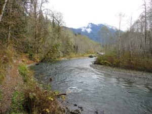
Quick Facts: Location: Mountain Loop Highway Land Agency: Mount Baker-Snoqualmie National Forest Roundtrip: 3.8 miles Elevation gain: 100 feet Green Trails Map: Mountain Loop Highway 111SX Contact: Darrington Ranger District: Mount Baker Snoqualmie National Forest Notes: Northwest Forest Pass or Interagency Pass required Access: From Darrington, follow Mountain Loop Highway for 9.0 miles to trailhead…
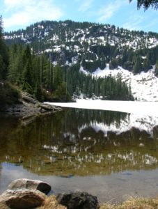
Quick Facts: Location: Twisp River Valley Land Agency: Okanogan-Wenatchee National Forest Roundtrip: 8.5 miles Elevation gain: 3,800 feet Green Trails Map: Stehekin, WA – No 82 Contact: Methow Valley Ranger District: Okanogan-Wenatchee National Forest Notes: NW Forest Pass or Interagency Pass required Access: From Twisp, follow Twisp River Road west for 21.8 miles to…