Region
Olympic Peninsula

Quick Facts: Location: Northeast Olympic Peninsula Land Agency: Olympic National Forest and Olympic National Park Roundtrip: 10.0 miles Elevation gain: 2800 feet Contact: Hood Canal Ranger District, Olympic National Forest; and Olympic National Park Green Trails Map: Olympics East no. 168SX Notes: Dogs are prohibited on trail in the national park Good to Know: dog-friendly…
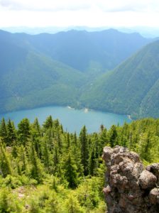
Quick Facts: Location:Mount Skokomish Wilderness, Southeast Olympic Peninsula Land Agency: Olympic National Forest Roundtrip: 6.7 miles Elevation gain: 3,500 feet Green Trails Maps: Olympic Mountains East No. 168SX Contact: Hood Canal District, Quilcene Notes: Wilderness regulations apply Access: From Shelton, travel north on US 101 for 15 miles to Hoodsport. Turn left onto SR 119…
Quick Facts: Location: Buckhorn Wilderness Land Agency: Olympic National Forest Roundtrip: 5.6 miles Elevation Gain: 1,100 feet Green Trails Map: Olympic Mountains East 168SX Recommended Guidebook: Day Hiking Olympic Peninsula 2nd edition (Mountaineers Books) Contact: Hood Canal District, Quilcene Olympic National Forest Access: From Sequim, head west 2.5 miles on US 101 turning left onto…
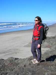
Quick Facts: Location: Long Beach Peninsula, Pacific County, WA Land Agency: Washington State Parks Contact: Cape Disappointment State Park Roundtrip to Beards Hollow: 1.0 mile Elevation Gain: 50 feet Roundtrip to North Head Lighthouse: 3 miles Elevation Gain: 300 feet Access: From Ilwaco, take Loop Spur State Road 100 in either direction to Beards Hollow…

Quick Facts: Location: Olympic National Forest, Hood Canal District Land Agency: National Forest Service Roundtrip: 2.0 miles Green Trails Map: Mount Tebo, WA No. 199 Elevation Gain: 200 feet Contact: Hood Canal District, Quilcene Good to know: Dog-friendly, Kid-friendly, snow free winter hike Access: From Shelton, head north on US 101 for 7 miles turning…

Quick Facts: Location: The Brothers Wilderness, east Olympic Peninsula Land Agency: Olympic National Forest Roundtrip: 10.6 miles Elevation gain: 2,300 feet Contact: Hood Canal Ranger District, Quilcene ; Olympic National Forest Green Trails Map: Olympics East no. 168SX Notes: Trail crosses a recent burn area, beware of falling snags especially during windy days Good to Know:…
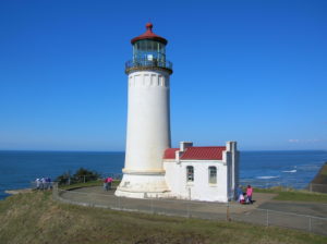
Location: Cape Disappointment State Park, Long Beach Peninsula Land Agency: Washington State Parks Roundtrip: 4.2 miles Elevation gain: 300 feet Contact: Cape Disappointment State Park Notes: Discover Pass required; Dogs must be leashed Good to Know: kid-friendly, snow free winter hike, historic Access: From Kelso follow SR 4 west to Naselle. Turn left onto SR…
Quick Facts: Location: Olympic Peninsula Coast Land Agency: Olympic National Park Roundtrip: 4.0 miles Green Trails Map: Olympic Beaches 99S Elevation Gain: None Contact: Olympic National Park Access: From Forks, drive west on SR 110 to Quillayute Prairie. Here SR 110 splits. Bear right (Mora Road), and drive 5.0 miles to the trailhead at road’s end.…

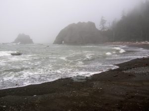
Quick Facts: Location: Olympic Coast near Forks Land Agency: National Park Service Roundtrip: 2.6 miles Elevation gain: 300 feet Contact: Olympic National Park Wilderness Information Center Green Trails Map: Olympic Beaches 99s Notes: Dogs Prohibited Recommended Guidebook: Day Hiking Olympic Peninsula 2nd edition (Mountaineers Books) Good to Know: kid-friendly, snow free winter hike; beach walking;…

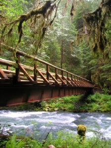
Quick Facts: Location: Buckhorn Wilderness, Olympic National Forest Land Agency: National Forest Service Roundtrip: 7.0 miles Elevation Gain: 600 feet Green Trails Map: Olympic Mountains East 168SX Note: NW Forest Pass or Interagency Pass required Access: From US 101 turn south onto Louella Road (directly across from Sequim Bay State Park entrance). In one mile…