Region
Olympic Peninsula

Quick Facts: Location: Buckhorn Wilderness, Olympic National Forest Land Agency: National Forest Service Roundtrip: 7.0 miles Elevation Gain: 600 feet Green Trails Map: Olympic Mountains East 168SX Note: NW Forest Pass or Interagency Pass required Access: From US 101 turn south onto Louella Road (directly across from Sequim Bay State Park entrance). In one mile…
Quick Facts: Location: Staircase Area, Olympic National Land Agency: National Park Service Roundtrip: 5.8 miles Elevation Gain: 3,200 feet Green Trails Map: Olympic Mountains East 168SX Notes: Dogs prohibited; National Park entry fee. Access: From Shelton, head north on US 101 for 15 miles to Hoodsport. Turn left onto SR 119 proceeding for 9.3 miles…

Quick Facts: Location: Olympic Coast, Olympic National Park Land Agency: National Park Service Roundtrip: 5.0 miles Elevation Gain: minimal Green Trails Map: La Push No. 163S Note: Dogs prohibited; Check tides – can only be done in a low tide; permits required to camp. Access: From Forks travel south on US 101 for 15 miles…
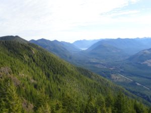
Stand watch over the Sol Duc Valley Quick Facts: Location: North Olympic Peninsula-Sol Duc Valley; Land Agency: Olympic National Forest; Roundtrip: 6.4 miles; Elevation gain: 2,400 feet; Contact: Olympic National Forest, Pacific District North, Forks; Notes: Discover Pass Required; Recommended Guidebook: Day Hiking Olympic Peninsula (2nd edition) Good to Know: Dog-friendly, Trail Less Traveled, Historic…

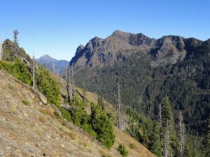
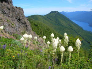
Quick Facts: Location: Northeast Olympic Peninsula Land Agency: Olympic National Forest Roundtrip: 7.0 miles Elevation gain: 900 feet Contact: Hood Canal Ranger District, Quilcene Green Trails Map: Olympic Mountains East no. 168SX Notes: wilderness rules apply Recommended Guidebook: Day Hiking Olympic Peninsula Good to Know: dog-friendly; kid-friendly; easy backpacking options, Buckhorn Wilderness Access: From US…
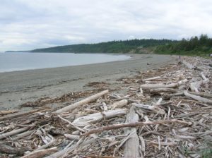
Quick Facts: Location: Marrowstone Island Land Agency: Washington State Parks Contact: Fort Flagler State Park Roundtrip: 5.6 miles Elevation Gain: 200 feet Access: From Kingston Ferry Terminal, follow SR 104 west for 15 miles turning right onto SR 19. Continue north for 9 miles to Chimicum turning right onto Irondale Road and proceeding 1.6 miles…
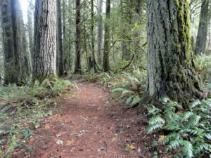
Stroll through groves of Old-growth above the Chehalis River Quick Facts: Location: Chehalis River Valley Land Agency: Washington State Parks Roundtrip: up to 3.0 miles Elevation gain: 300 feet Contact: Rainbow Falls State Park Notes: Discover Pass required; dogs must be leashed Access: From Chehalis (exit 77 on I-5) follow SR 6 west for 16…
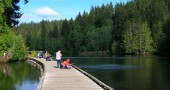
Quick Facts: Location: Montesano, Olympic Peninsula Land Agency: Washington State Parks Roundtrip: 4.9 miles Elevation Gain: 220 feet Access: From US 12 in Montesano, head north on Main Street past the county courthouse. Turn left onto Spruce Avenue proceeding three blocks. Then turn right on 3rd Street which becomes Sylvia Lake Road for 1.2 miles to…
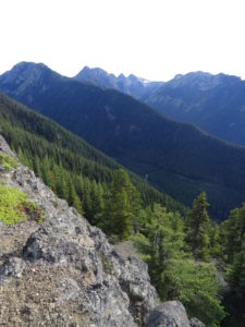
Quick Facts: Location: North Olympic Peninsula Land Agency: Olympic National Forest Roundtrip: 12.7 miles Elevation gain: 3350 feet Contact: Olympic National Forest, Pacific Ranger District, Forks, Green Trails Map: Green Trails Lake Crescent No. 101 Notes: Northwest Forest Pass or Interagency Pass required Access: From Port Angeles, follow US 101 west for 32 miles to…
Quick Facts: Location: Buckhorn Wilderness, Northeast Olympic Peninsula Land Agency: Olympic National Forest Roundtrip: 7.8 miles Elevation gain: 3,000 feet Green Trails Maps: Olympic Mountains East No. 168SX Recommended Guidebook: Day Hiking Olympic Peninsula 2nd edition (Mountaineers Books) by Craig Romano Contact: Hood Canal District, Olympic National Forest Quilcene Access: Take US 101 to Louella…