Region
Puget Sound Islands & Lowlands
Walk across Maple Valley through a “wilderness” park Quick Facts: Location: Maple Valley, WA Distance: 3.3 miles one way Contact: King County Parks Elevation Gain: 250 feet Notes: Dogs permitted on leash Trailhead directions: From Seattle follow I-5 to I-405 and take Exit 4 in Renton. Then drive SR 169 south for 11.3 miles turning…
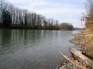
Historic prairie at the Forks of the Snoqualmie Quick Facts: Location: North Bend, WA Distance: 1.5 miles of trails Elevation Gain: minimal Contact: Si View Metropolitan District Green Trails Map: Mount Si NRCA no. 206S Notes: Dogs permitted on leash Trailhead directions: From Seattle follow I-90 east to Exit 27. Turn left onto Winery Road…
Peaceful wandering near the Oyster Dome Quick Facts: Location: Blanchard State Forest Distance: 7.5 miles roundtrip Elevation Gain: 1,500 feet Contact: Washington Department of Natural Resources Map: Square One Maps Chuckanut Recreation Area Notes: Discover Pass required to park at trailheads Trailhead directions: From I-5 Exit 240 in Alger head north on Lake Samish Road…
Quick Facts: Location: Edmonds Waterfront Land Agency: City of Edmonds Parks and Recreation Roundtrip: 1.8 miles Elevation Gain: Level Access: From I-5 follow SR 104 west towards the Edmonds-Kingston Ferry. One stoplight before the ferry terminal, turn left onto Dayton Street. Then continue for .1 mile to just before the railroad crossing. Turn left here…
Quick Facts: Location: Snohomish Valley Land Agency: Snohomish County Parks Roundtrip: 5.2 miles Elevation gain: 650 feet Contact: Snohomish County Parks Map: Snohomish County Parks Notes: Dogs permitted on leash Good to know: Dog-friendly, kid-friendly, snow-free winter hike, good trail running Access: From Everett follow US 2 to SR 9. Head south on SR 9 and exit…
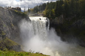
Hike to the base of the falls where heaven connects to earth Quick Facts: Location: Snoqualmie Valley Distance: 1.4 miles Elevation Gain: 280 feet Contact: Puget Sound EnergyDetailed Information: Urban Trails Eastside (Mountaineers Books) Green Trails Map: Rattlesnake Mountain/ Mountains to Sound Greenway No. 205S Notes: dogs permitted on leash. Parking lot on west side…
Wander the former farm grounds of a state mental health hospital Quick Facts: Location: Skagit Valley Distance: more than 7.0 miles of trails Elevation Gain: up to 400 feet Contact: Skagit County ParksDetailed Information: Urban Trails Bellingham (Mountaineers Books) Notes: dogs permitted on leash; park open dawn to dusk. Access: From Exit 230 on I-5…
Quick Facts: Location: Everett Land Agency: Everett Parks and Recreation Roundtrip: up to 5.0 miles Elevation gain: none Difficulty: Easy Contact: Everett Parks and Recreation Department Notes: Parking fee $2.00 (credit card or exact amount cash) Passenger Ferry runs on Wednesday through Sunday from July 5th until September 3rd and requires a reservation ($3 per…
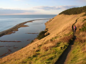
Quick Facts: Location: Whidbey Island Land Agency: National Park Service and Washington State Parks Roundtrip: 5.2 miles Elevation Gain: 260 feet Contact: Ebey’s Landing National Historical Reserve Suggested Guidebook: Urban Trails Everett Special note: Dogs permitted on leash. Access: Take Washington State Ferry from Mulkiteo to Clinton on Whidbey Island. Continue north on SR 525…
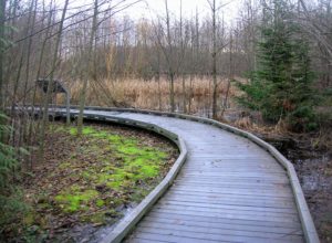
Quick Facts: Location: Everett Land Agency: Snohomish County Roundtrip: 1.8 miles Elevation gain: none Difficulty: Easy Contact: Friends of Narbeck Wetland Sanctuary Notes: Dogs must be leashed; open 7 a.m. to dusk Access: From Everett follow SR 526 west 2.5 miles exiting onto Seaway Boulevard. Proceed for 1.0 mile north. Entrance is on right, across…