Region
Puget Sound Islands & Lowlands

Quick Facts: Location: Edmonds Waterfront Land Agency: City of Edmonds Parks and Recreation Roundtrip: 1.8 miles Elevation Gain: Level Access: From I-5 follow SR 104 west towards the Edmonds-Kingston Ferry. One stoplight before the ferry terminal, turn left onto Dayton Street. Then continue for .1 mile to just before the railroad crossing. Turn left here…
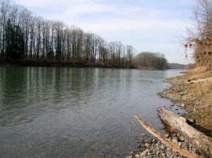
Quick Facts: Location: Snohomish Valley Land Agency: Snohomish County Parks Roundtrip: 5.2 miles Elevation gain: 650 feet Contact: Snohomish County Parks Map: Snohomish County Parks Notes: Dogs permitted on leash Good to know: Dog-friendly, kid-friendly, snow-free winter hike, good trail running Access: From Everett follow US 2 to SR 9. Head south on SR 9 and exit…
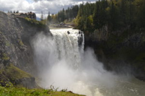
Hike to the base of the falls where heaven connects to earth Quick Facts: Location: Snoqualmie Valley Distance: 1.4 miles Elevation Gain: 280 feet Contact: Puget Sound EnergyDetailed Information: Urban Trails Eastside (Mountaineers Books) Green Trails Map: Rattlesnake Mountain/ Mountains to Sound Greenway No. 205S Notes: dogs permitted on leash. Parking lot on west side…

Wander the former farm grounds of a state mental health hospital Quick Facts: Location: Skagit Valley Distance: more than 7.0 miles of trails Elevation Gain: up to 400 feet Contact: Skagit County ParksDetailed Information: Urban Trails Bellingham (Mountaineers Books) Notes: dogs permitted on leash; park open dawn to dusk. Access: From Exit 230 on I-5…
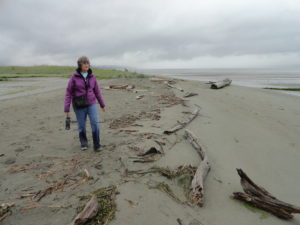
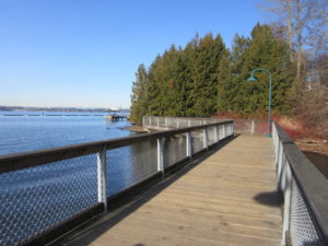
Quick Facts: Location: Everett Land Agency: Everett Parks and Recreation Roundtrip: up to 5.0 miles Elevation gain: none Difficulty: Easy Contact: Everett Parks and Recreation Department Notes: Parking fee $2.00 (credit card or exact amount cash) Passenger Ferry runs on Wednesday through Sunday from July 5th until September 3rd and requires a reservation ($3 per…
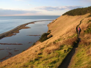
Quick Facts: Location: Whidbey Island Land Agency: National Park Service and Washington State Parks Roundtrip: 5.2 miles Elevation Gain: 260 feet Contact: Ebey’s Landing National Historical Reserve Suggested Guidebook: Urban Trails Everett Special note: Dogs permitted on leash. Access: Take Washington State Ferry from Mulkiteo to Clinton on Whidbey Island. Continue north on SR 525…
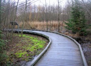
Quick Facts: Location: Everett Land Agency: Snohomish County Roundtrip: 1.8 miles Elevation gain: none Difficulty: Easy Contact: Friends of Narbeck Wetland Sanctuary Notes: Dogs must be leashed; open 7 a.m. to dusk Access: From Everett follow SR 526 west 2.5 miles exiting onto Seaway Boulevard. Proceed for 1.0 mile north. Entrance is on right, across…
The crown jewel of Lake Washington parks Quick Facts: Location: Lake Washington Round Trip: 1.5 miles of trails Elevation Gain: minimal Contact: City of Renton Parks Commission Detailed Information: Urban Trails Seattle (Mountaineers Books) Notes: Dogs prohibited. Park open 8:00 am to dusk Access: Take Exit 5 on I-405. Then head west on N Southport…
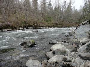
Hike along rapids at the mouth of the Green River gorge Quick Facts: Location: Kanaskat-Palmer State Park Land Agency: Washington State Parks Round Trip: 2.5 miles Elevation Gain: 175 feet Contact: Kanaskat-Palmer State Park Detailed Information: Urban Trails Tacoma (Mountaineers Books) Notes: Discover Pass required. Dogs permitted on leash. Green River contains strong currents—exercise caution…

Savor Salish Sea views from ledges high on Lummi Mountain Quick Facts: Location: Lummi Island Round Trip: 3.6 miles Elevation Gain: 1,030 feet Contact: Lummi Island Heritage Trust Detailed Information: Day Hiking San Juans and Gulf Islands (Mountaineers Books) Map: online Notes: dogs prohibited; all visitors must sign register; day light hours only, group size…