Region
Puget Sound Islands & Lowlands
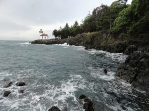
Orcas, old quarries, and a beautiful lighthouse Quick Facts: Location: San Juan Island Land Agency: Washington State Parks and San Juan County Conservation Land Bank Roundtrip: 2.2 miles Elevation Gain: 265 feet Contact: Lime Kiln State Park or San Juan County Conservation Land Bank Detailed Information: Day Hiking the San Juans and Gulf Islands (Mountaineers Books) Notes: Discover…

Quick Facts: Location: Kitsap Peninsula Land Agency: City of Belfair, Washington Distance: 3.0 miles of trails Elevation Gain: 40 feet Recommended Resource: Urban Trails Kitsap Notes: Trail open dawn to dusk. Dogs are prohibited. Access: From Bremerton head west on SR 3 to Belfair. Proceed one mile beyond the junction with SR 300 to the…
Location: Maltby Land Agency: Snohomish County Parks Roundtrip: 0.6 mile Elevation gain: minimal Contact: Snohomish County Parks; map available on line Notes: Dogs must be on a leash Access: From SR 522 in Maltby (5.0 miles east of Woodinville; 8.0 miles west of Monroe) head east on Paradise Lake Road for 1.7 miles to trailhead.…
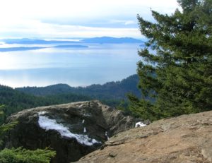
Quick Facts: Location: Chuckanut Mountains Land Agency: Washington Department of Natural Resources Roundtrip: 6.5 miles Elevation Gain: 1,900 feet Special Note: Oyster Dome can be hazardous in icy and wet conditions. Trail can be extremely popular, opt for a weekday visit. Contact: Washington DNR, Northwest Region; www.dnr.wa.gov Access: Trailhead is located just past milepost 10…
Park rich with views, history, and wildlife on Oro Bay Quick Facts: Location: Anderson Island Land Agency: Anderson Island Park and Recreation Department Round Trip: 2.5 mile loop Elevation Gain: minimal Contact: Anderson Island Park and Recreation Department Detailed Information: Urban Trails Tacoma (Mountaineers Books) Notes: Dogs prohibited Access: From Steilacoom–Anderson Island Ferry terminal take…
Quick Facts: Location: Lynnwood Land Agency: City of Lynnwood Parks and Recreation Roundtrip: 1.2 miles Elevation gain: none Difficulty: Easy Contact: Lynnwood Parks and Recreation Department; (425-771-4030) Notes: Dogs must be leashed Access: From Seattle take I-5 to exit 181. Turn left onto 44th Ave NW. At third light turn left onto SR 524 (196th…
Supreme birdwatching on the Skagit River Delta Quick Facts: Location: Fir Island, Skagit County Land Agency: Washington Department of Fish and Wildlife (WDFW) Round Trip: 1.9 miles of trails Elevation Gain: minimal Contact: Washington Department of Fish and Wildlife (WDFW) Detailed Information: Urban Trails Bellingham (Mountaineers Books) Notes: Discover Pass or WDFW Vehicle Access Pass…

Quick Facts: Location: San Juan Islands National Monument Land Agency: Bureau of Land Managment Roundtrip: 3.8 miles Elevation gain: 380 feet Contact: San Juan Islands National Monument, Spokane District Office BLM Notes: Dogs permitted on leash; do not park beyond Agate Beach Park; access is via private property which owners have generously granted permission—stay on…
Quick Facts: Location: Sammamish Plateau Land Agency: King County Parks Distance: more than 12.0 miles of trails Elevation Gain: up to 325 feet Contact: King County Parks Notes: dogs permitted on leash; trails also open to horses and mountain bikes Map: Click Here Recommended Guidebook: Urban Trails Eastside (Mountaineers Books) Access: From Bellevue follow SR…
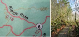
Quick Facts Location: Lord Hill Park near Snohomish Land Agency: Snohomish County Parks Roundtrip: 3.5 miles High Point: 650 feet Elevation gain: 400 feet Difficulty: moderate Contact: Snohomish County Parks Notes: Dogs must be on leash; trails open to bikes and horses Access: From the city of Snohomish, exit SR 9 onto 2nd Street. Proceed…