Archives

Quick Facts: Location: Kettle River Range Land Agency: Colville National Forest Roundtrip: 6.0 miles Elevation Gain: 1615 feet Contact: Colville National Forest, Three Rivers Ranger District-Kettle Falls Access: From Republic, head east on SR 20 for 21 miles turning left onto FR 2030 (Albion Hill Road). From Kettle Falls, head west on SR…

Quick Facts: Location: Mark O Hatfield Wilderness, Columbia River Gorge National Scenic Area, Oregon Land Agency: National Forest Service Roundtrip: 2.4 miles Elevation Gain: 575 feet Green Trails Map: Columbia River Gorge -West No 428S Contact: Mount Hood National Forest, Hood River Ranger Station Notes: Wilderness rules apply Access: From…

Quick Facts: Location: Wild Sky Wilderness, Skykomish River Valley Land Agency: National Forest Service Roundtrip: 8.6 miles Elevation Gain: 1,750 feet Green Trails Map: Alpine Lakes West 176S Contact: Skykomish Ranger District: Mount Baker-Snoqualmie National Forest Notes: Northwest Forest Pass or Interagency Pass required. Access: From Everett, head east 41 miles…
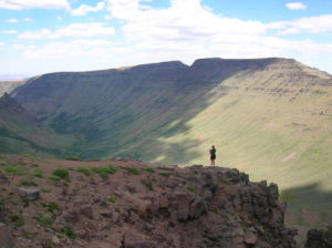
Quick Facts: Location: Great Basin, Eastern Oregon Land Agency: Steens Mountain Cooperative Management and Protection Area (BLM) Roundtrip: Kiger Gorge Rim; up to 4.0 miles Elevation gain: Up to 500 feet Difficulty: moderate Contact: BLM Burns Office Access: From Burns, Oregon travel 60 miles south to Frenchglen. Take Steens Mountan…
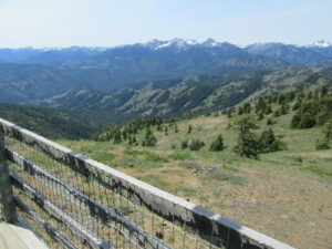
Look out over the Methow Valley and beyond Quick Facts: Location: Methow Valley, WA Distance: 3.0 miles one way Elevation Gain: 1170 feet Contact: Okanogan-Wenatchee National Forest, Methow Valley Ranger District Maps: Green Trails Methow Valley 51SX Recommended Guidebook: Day Hiking North Cascades (Mountaineers Books) Notes: trail open to mountain…

Quick Facts: Location: Victoria—Langford, BC Land Agency: Capital Regional District Parks Roundtrip: 2.0 miles/ 3.2 km Elevation gain: 865 feet/ 264 m Maps: CRDP site Contact: Capital Regional District Parks Notes: dogs permitted on leash; please stay on trail to protect rare plants Access: From Victoria, follow Trans-Canada Highway 10.5…

Quick Facts Location: Franklin County, Eastern Washington Land Agency: Bureau of Land Management Roundtrip: 2.0 miles Elevation gain: 200 feet Difficulty: Moderate Contact: Bureau of Land Management (BLM) Spokane Office Notes: All approaches to this wilderness area are currently via private roads and land. The southern approach cannot be recommended due…
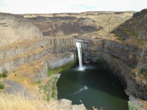
Quick Facts: Location: Channeled Scablands Eastern Washington Land Agency: Washington State Parks Roundtrip: 1.3 miles Elevation Gain: 150 feet Contact: Washington State Parks Guidebook: Day Hiking Eastern Washington (Mountaineers Books) Notes: Discover Pass required. Dogs permitted on leash. Watch for rattlesnakes Access: From Pasco, take US 395 north to Connell. Then follow SR…

Location: Columbia River Gorge National Scenic Area Land Agency: Friends of the Columbia Gorge Roundtrip: 6.8 miles Elevation gain: 1,500 feet Contact: Friends of the Columbia Gorge Notes: Dogs permitted on leash; Beware ticks, rattlesnakes, and poison oak; parking limited especially on weekends Green Trails Map: Columbia River Gorge East…
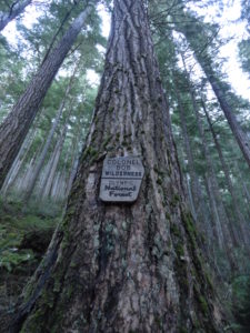
Quick Facts: Location: Colonel Bob Wilderness Land Agency: Olympic National Forest Roundtrip: 3.8 miles Elevation Gain: 1100 feet Contact: Olympic National Forest, Pacific Ranger District, Quinault Green Trails Map: Mt Christie No. 166 Recommended Guidebook: Day Hiking Olympic Peninsula 2nd edition (Mountaineers Books) Access: From Hoquiam, travel north on US 101 for 38…