Region
Urban Trails
Quick Facts: Location: Mountlake Terrace, southern Snohomish County Land Agency: City of Mountlake Terrace Roundtrip: 2.0 miles Elevation Gain: 125 feet Access: From Seattle: drive I-5 north to exit 178. Turn right and follow 236th Street SW for 0.7 mile. Then turn left onto 48th Ave W and drive north 0.2 mile to park and parking on your…
Quick Facts: Location: Edmonds Land Agency: Edmonds Parks and Recreation Department Roundtrip: About 1.5 miles of trails Elevation Gain: up to 300 feet Contact: Edmonds Parks and Recreation Access: From Everett or Seattle take I-5 to Exit 179. Then head west on 220th Street SW for 2.1 miles. Turn right and head north on 96th Ave…
Quick Facts: Location: Olympia, Washington Land Agency: City of Olympia Parks and Recreation Roundtrip: 2.5 miles Elevation Gain: 300 feet Notes: Dogs must be on a leash. Access: From Lacey, follow I-5 south to Olympia taking Exit 105B to Plum Street. From Tumwater, follow I-5 north to Olympia taking Exit 105. Turn right onto Henderson…
Quick Facts: Location: Skagit Valley Land Agency: Skagit County Parks Round Trip: more than 5 miles of trails Elevation Gain: up to 150 feet Contact: Skagit County Parks and Recreation Guidebook source: Urban Trails Bellingham (Mountaineers Books) Notes: dogs permitted on leash; trails shared by mountain bikers Access: From Exit 232 on I-5 drive Cook Road…
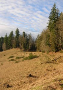
Quick Facts: Location: Lord Hill Regional Park Land Agency: Snohomish County Parks Roundtrip: 2.0 miles Elevation Gain: 275 feet Access: From Monroe, exit SR 522 onto Main Street heading west and immediately coming to a roundabout. Bear right onto Tester Road and proceed 3.0 miles to a T-intersection just after passing under SR 522. Turn left and proceed to South…

Quick Facts: Location: Northern Snohomish County, near Stanwood Land Agency: Pacific Denkmann Company Pilchuck Tree Farm Roundtrip: 3.2 miles Elevation Gain: 400 feet Contact: Pilchuck Recreation Association: www.pilchuckra.org Notes: All trail users MUST sign a liability release and have it on file to use these trails. Download here and mail (with $2 donation) to Pilchuck Recreation Association. Dogs…
Quick Facts Location: SR 9 just south of Skagit County line Land Agency: Snohomish County Parks Roundtrip: 8.0 miles Elevation Gain: Minimal Access: From Arlington (junction of SR 530-SR 9), follow SR 9 north for 7.6 miles turning left into park. Proceed .1 mile to parking area. Notes: Dogs must be on leash. Contact: Snohomish…
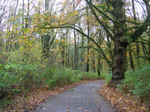
Quick Facts: Location: City of Monroe Land Agency: Monroe Parks and Recreation Department Roundtrip: 1.5 miles Elevation Gain: Minimal Notes: Dogs must be on leash; Trail is prone to flooding during periods of heavy rain. Access: From Everett follow US 2 east to Monroe. Turn right onto SR 203 (Lewis Street). Proceed past Main Street traffic lights and within a short…
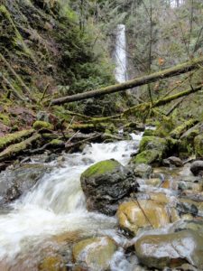
Quick Facts: Location: Near Lake Roesiger between Monroe and Granite Falls Land Agency: Washington DNR Roundtrip: 2.0 miles Elevation gain: 200 feet Contact: Washington DNR Notes: Do not block gate, nor drive past it if open. Active logging area, be alert to trucks on roadway and yield right-of-way. Access: From Monroe, follow Woods Road north…
- « Previous
- 1
- …
- 9
- 10
- 11