Explorer Falls–It's an easy search to find these falls

Quick Facts:
Location: Near Lake Roesiger between Monroe and Granite Falls
Land Agency: Washington DNR
Roundtrip: 5.2 miles
Elevation gain: 700 feet
Contact: Washington DNR
Notes: Discover Pass Required. Do not block gates, nor drive past it if open. Active logging area, be alert to trucks on roadway and yield right-of-way.
Access: From Monroe, follow Woods Road north for 10.3 miles to junction. Turn right onto SW Lake Roesiger Road and in .1 mile bear right onto South Lake Roesiger Road. Continue for 2.3 miles turning right onto Monroe Camp Road (signed for Camp Brinkley). Follow this road for 1.6 miles to trailhead on your left. Hike begins on dirt road.
Good to know: kid-friendly, dog-friendly, snow-free winter hike
Named for the Explorer Search and Rescue teams that frequent this area for training exercises; you’ll enjoy exploring these falls as well. The Explorer teams from the nearby Camp Edward (formerly Camp Brinkley) have designed a system of trails above the falls as well that call out to be explored. The hike to the falls used to be fairly short, but new access now makes it more than twice as long. It’s still a fairly easy hike though–albeit mainly on forest roads. The hike beyond the falls however requires a little more time and energy.
Start your adventure by walking up the gated road. Continue up the road gradually climbing and curving around a small pond. Bear right at a junction and then take a left at the next junction. After a long straight shot come to another junction. Turn right here and at 2.6 miles from your start eventually come to the falls in a small ravine on your left.
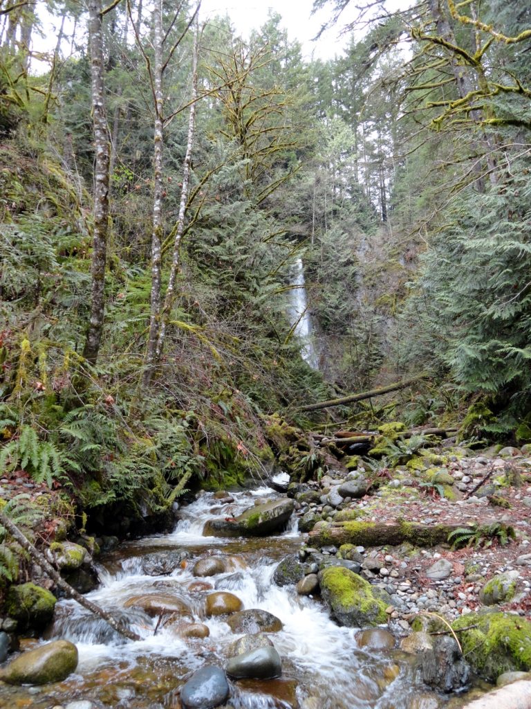
Most of the land here to the south surrounding Lake Chaplain is owned by the city of Everett and is off-limits to public entry. The 50-plus foot waterfall crashes down from a steep ledge Cross the creek on a makeshift but somewhat sturdy bridge for even better viewing of the impressive waterfall tucked within a tight rocky nook. You should be able to get a decent view from this spot. But if you’re inclined to get a close-up, be careful walking over downed logs and slippery rocks to reach the splash pool.
If you’re up for more exercise, notice the trail continuing just down from the bridge. Follow it; switch backing up a steep heavily-timbered hillside. Reach a good viewpoint of the falls plummeting below. Keep hiking cresting a small rib and then dropping down to the creek above the falls. It is possible to walk out on the ledge above the falls, but use extreme caution as it is exposed and potentially dangerous.
If the creek level isn’t too high wade or rock hop across it and continue following good trail up steep slopes through mature second growth. At about one mile from the falls, you’ll come to the edge of an old cut and to an area known locally as Top of the World. The trail splits here and both ways lead to a decommissioned logging road. Follow the old road passing wetland pools and make a long sweeping turn coming to a good vantage point (el. 1,650-feet) with views across the Snohomish River Valley to the Seattle skyline. Keep a lookout for bluebirds, as they nest in the vicinity. This spot makes for a good lunch and turning around spot. Logging roads continue all the way to Echo Lake, but navigation and crowding alders can make travel a little challenging.

For detailed information on other snow free hikes around western Snohomish County and Whidbey and Camano Islands–pick up a copy of Urban Hikes Everett.