Lake Serene — Placid lake tucked beneath the terrifying towers of Mount Index
Quick Facts:
Location: US 2 near Index
Land Agency: Mount Baker-Snoqualmie National Forest
Roundtrip: 7.2 miles
Elevation gain: 2020 feet
Green Trails Maps: Index WA- No. 142
Recommended Guidebook: Day Hiking Central Cascades 2nd edition (Mountaineers Books)
Contact: Skykomish Ranger District: Mount Baker Snoqualmie National Forest
Notes: NW Forest Pass or Interagency Pass required
Access: From Everett follow US 2 east for 34 miles to just before Skykomish River Bridge (near Milepost 34). Turn right onto Mount Index Road (FR 6020) proceeding 0.3 mile. Turn right on spur-road signed “Lake Serene Trail 1068,” reaching trailhead in 0.1 mile. If parking lot is full, head to another trail. Do not park along road.
Good to Know: Alpine lake, waterfalls, old growth, kid-friendly
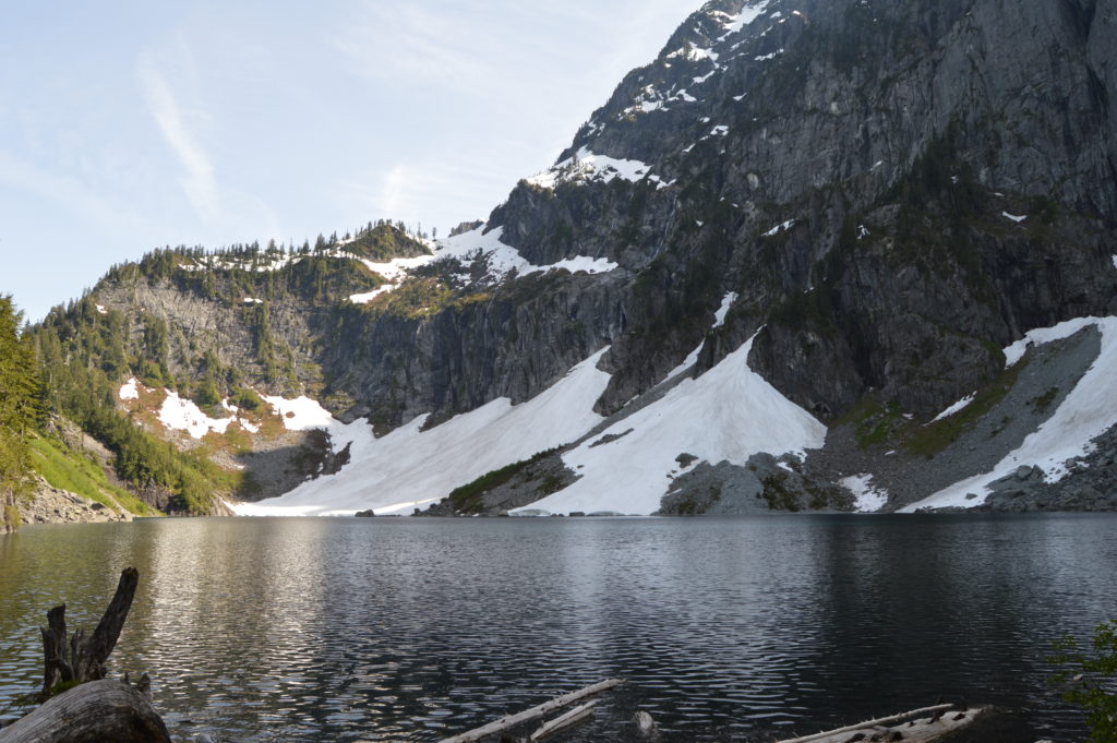
Towering and formidable, Mount Index is the most awe-inspiring sight along US 2. But, softening the mountain’s stark appearance is Bridal Veil Falls. Emanating from beneath Index’s austere crags, the tiered and tumbling cataract drapes over granite slabs. And above the falls nestled beneath those austere spires is a beautiful large lake. Both the falls and the lake make worthy and satisfying hiking destinations. But take note, the word is out on this hike—expect lots of company.
The trail starts on an old road lined with mossy maples and alders. Cross a couple of creeks and gradually ascend a thickly forested slope. Bear right at another old road and come to a junction at 1.7 miles. The trail right heads a steep half mile to Bridal Veil Falls—a worthy side trip. For Lake Serene continue left dropping about 60 feet into a damp ravine. Here, cross Bridal Veil Creek on a well-built bridge; then scoot beneath some steep ledges sporting a pretty cascade.
Now prepare for a workout. On solid tread that occasionally utilizes stone steps and rock cribbing, the trail steeply ascends. The way is rocky at times and makes for slow going. Catching your breath, admire the surrounding mammoth old cedars and Sitka spruce. The latter is a rarity this far from the coast, attesting to the area’s ample rainfall.
After a long sweep east and a long sweep west, the trail skirts under, over and around cliffs on its way to the lake. Enjoy fine views of the valley below as well as out to Ragged Ridge and other peaks of the Wild Sky Wilderness. Eventually reach Lake Serene tucked in a tight basin beneath the ramparts and parapets of fortress Index.
Cross the lake’s outlet on a sturdy bridge and come to a junction. Right leads a scant 0.1 mile to a valley overlook. Left leads 0.1 mile to the ever popular Lunch Rock on the shores of Lake Serene. Here among fellow admirers, stare straight up the 3,000 vertical foot stark walls surrounding the lake—not serene at all! But when the basin is calm, those imposing rock faces delicately reflect upon the lake’s surface. Now, that’s serene and quite a sight!
For more detailed information on this hike and many other along US 2, pick up a copy of my best selling Day Hiking Central Cascades 2nd edition (Mountaineers Books).