Image Lake — jewel in the heart of the Glacier Peak Wilderness
Quick Facts:
Location: Glacier Peak Wilderness
Land Agency: Mount Baker-Snoqualmie National Forest
Roundtrip: 33.0 miles
Elevation Gain: 4,700 feet
Green Trails Map: Mountain Loop Highway 111SX
Contact: Darrington Ranger District: Mount Baker Snoqualmie National Forest
Notes: NW Forest or Interagency Pass required; No camping within ¼ mile of Image Lake—use established campsites; no fires at lake; respect re-vegetation and closed areas; lake closed to swimming during times of low volume.
Access: From Darrington travel north on SR 530 for 7.5 miles turning right onto FR 26 (Suiattle River Road). Follow FR 26 for 22.5 miles to its end at the Suiattle Trailhead.
Good to Know: dog-friendly, backpacking, wilderness rules apply, exceptional old growth, exceptional wildflowers
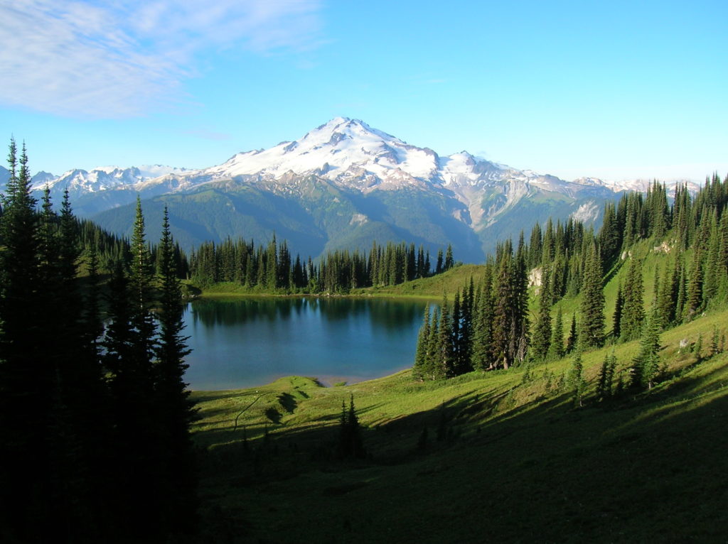
Anyone who has ever sat by Image Lake on a clear and calm summer morning witnessing the 10,541’ volcano known as Glacier Peak mirrored in its placid waters never forgets such a dramatic scene. For here deep in the Glacier Peak Wilderness in a 6,100-foot basin high on Miners Ridge, you’d be hard-pressed to find a more beautiful spot within the entire Cascade Range. Image Lake represents the very essence of the sprawling unspoiled 575,000-acre Glacier Peak Wilderness. This is the supreme hiking destination in Snohomish County. A trek into the very heart of the finest natural scenery Snohomish has to offer. And with most things special, it’s not easily attained. Getting to Image Lake requires a multi-day trek and is not for beginning hikers.
From the trailhead, start hiking east on the Suiattle River Trail soon entering the sprawling Glacier Peak Wilderness. Pass through groves of majestic old growth forest; some of the finest stretches of primeval forest in the state. The trail carries on through spectacular groves of old-growth forest following alongside the Suiattle River.
Cross several boot-wetting creeks before coming to Canyon Creek spanned by an impressive suspension bridge. This is a good spot for day hikers to turn around. Beyond, the trail soon reaches the Pacific Crest Trail. Now head left on the PCT still following (albeit above) the Suiattle River. Come to another junction. Go left onto the Miners Ridge Trail and say goodbye to easy rambling. Via copious switchbacks make an arduous ascent up Miners Ridge.
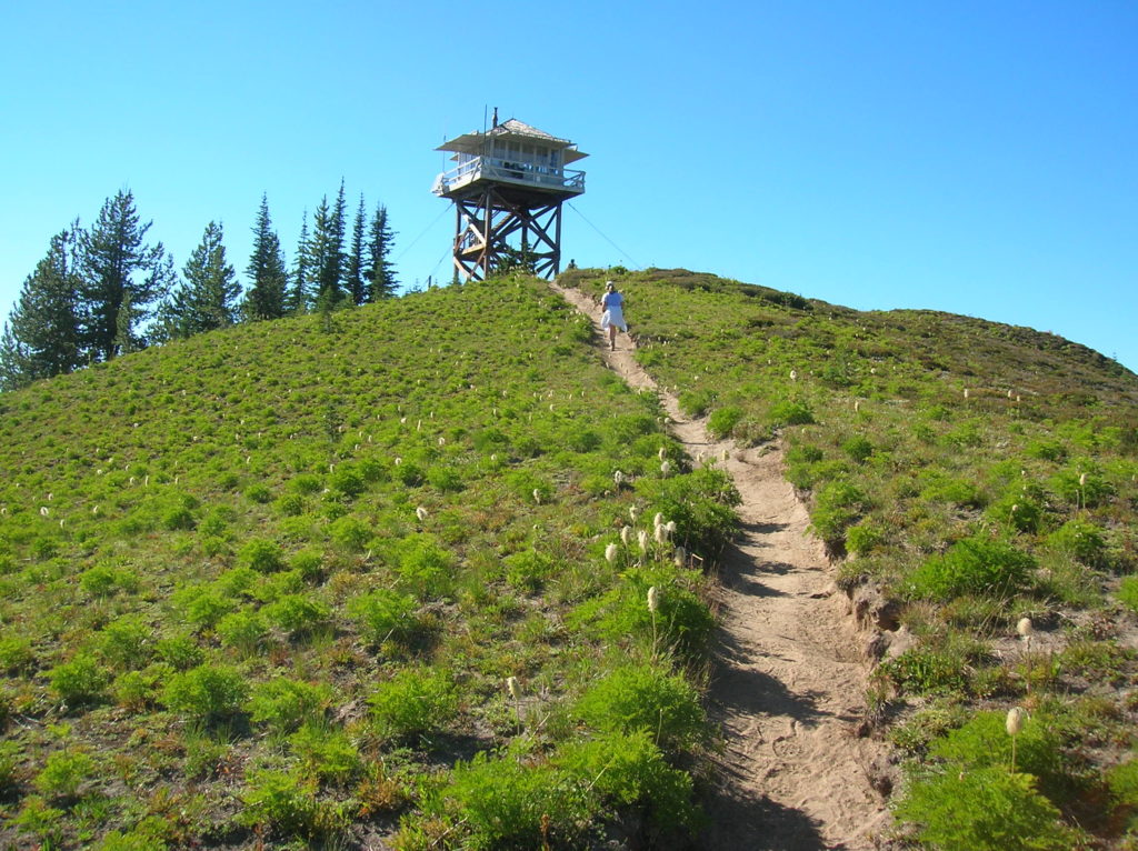
At nearly 15 miles finally crest Miners Ridge. Before continuing to the lake, make a short side trip to the 6,208-foot Miners Ridge Fire Lookout. Here, reap some of the finest views anywhere. Stare straight down the emerald Suiattle Valley—and straight up the snowy white slopes of 10,541-foot Glacier Peak.
Retrace your steps to the junction and then hike through berry patches and meadows along the ridge to a junction. Here a trail departs right for Image Lake and camps. The trail left contours around and above the lake providing vantages for capturing the famous image of Image Lake reflecting Glacier Peak. This trail eventually meets up again with the lower trail and camp spur. Set up, spend a few days and consider many side trips and return variations. There are few places on the planet more beautiful than this—savor it!
For detailed information on this hike (including mileage, elevation and maps) and other stunning hikes throughout the state, pick up a copy of my best selling 100 Classic Hikes Washington (Mountaineers Books)!
Image Lake is also featured in my Backpacking Washington 2nd edition (Mountaineers Books)