Archives
Quick Facts: Location: Mountain Loop Highway near Barlow Pass Land Agency: Mount Baker-Snoqualmie National Forest Roundtrip: 17.0 miles Elevation gain: 3,900 feet Green Trails Map: Mountain Loop Highway no. 111SX Contact: Darrington Ranger District: Mount Baker Snoqualmie National Forest Notes: Northwest Forest Pass or Interagency Pass required; A washout…
Quick Facts: Location: Skykomish Valley Land Agency: National Forest Service Round Trip: 3.8 miles Elevation Gain: 800 feet Contact: Skykomish Ranger District, Mount Baker-Snoqualmie National Forest Green Trails Maps: Green Trails, Alpine Lakes West Stevens Pass No 176S Notes: Northwest Forest pass or Interagency pass required; dogs must be leashed; wilderness…

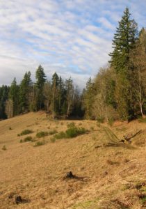
Location: Mountain Loop Highway Land Agency: Mount Baker-Snoqualmie National Forest Roundtrip: 5.2 miles High Point: 4,650 feet Elevation gain: 1,900 feet Difficulty: challenging Green Trails Maps: Mountain Loop Highway No. 111SX Contact: Darrington Ranger District: Mount Baker Snoqualmie National Forest Access: Take Exit 208 off of I-5 following SR 530 east…
Quick Facts: Location: Mountain Loop Highway near Darrington Land Agency: Mount Baker-Snoqualmie National Forest Roundtrip: 7.0 miles Elevation Gain: 900 feet Green Trails Map: Mountain Loop Highway no.111SX Note: NW Forest Pass required Access: From Granite Falls follow the Mountain Loop Highway east for 31 miles to Barlow Pass and end of pavement.…

Quick Facts: Location: Mount Rainier National park Land Agency: National Park Service One way: 9.0 miles Elevation Loss: 2,200 feet Contact: Mount Rainier National Park Green Trails Maps: Mount Rainier National Park 269S Notes: National Park entry fee; Dogs prohibited; Keep children nearby around waterfalls and creek sides as a slip…
Quick Facts: Location: Mountain Loop Highway near Granite Falls Land Agency: Mount Baker-Snoqualmie National Forest Roundtrip: 2.0 miles Elevation gain: 300 feet Difficulty: easy (with some rough footing) Green Trails Map: Mountain Loop Highway 111SX Contact: Darrington Ranger District: Mount Baker-Snoqualmie National Forest Access: From Granite Falls, follow the Mountain Loop…
Quick Facts: Location: Lord Hill Regional Park Land Agency: Snohomish County Parks Roundtrip: 2.0 miles Elevation Gain: 275 feet Access: From Monroe, exit SR 522 onto Main Street heading west and immediately coming to a roundabout. Bear right onto Tester Road and proceed 3.0 miles to a T-intersection just after passing under SR 522. Turn…
Quick Facts: Location: Mountain Loop Highway Land Agency: Mount Baker-Snoqualmie National Forest Roundtrip: 3.8 miles Elevation gain: 100 feet Green Trails Map: Mountain Loop Highway 111SX Contact: Darrington Ranger District: Mount Baker Snoqualmie National Forest Notes: Northwest Forest Pass or Interagency Pass required Access: From Darrington, follow Mountain Loop Highway…

Quick Facts: Location: Northern Snohomish County, near Stanwood Land Agency: Pacific Denkmann Company Pilchuck Tree Farm Roundtrip: 3.2 miles Elevation Gain: 400 feet Contact: Pilchuck Recreation Association: www.pilchuckra.org Notes: All trail users MUST sign a liability release and have it on file to use these trails. Download here and mail (with $2…
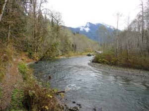
Quick Facts: Location: Skykomish River Valley near Index Land Agency: Washington State Parks Roundtrip: 2.6 miles Elevation gain: 1,300 feet Green Trails Maps: Alpine Lakes Stevens Pass Map 176S Contact: Washington State Parks Notes: Discover Pass required; Dogs must be leashed Access: From Everett follow US 2 east for 36…