Copper Butte via Old Stage Trail– Take a historic route to the rooftop of the Kettle River Range

Quick Facts:
Location: Kettle River Range
Land Agency: Colville National Forest
Roundtrip: 6.0 miles
Elevation Gain: 1615 feet
Contact: Colville National Forest, Three Rivers Ranger District-Kettle Falls
Access: From Republic, head east on SR 20 for 21 miles turning left onto FR 2030 (Albion Hill Road). From Kettle Falls, head west on SR 20 for 22 miles turning right onto FR 2030. Follow FR 2030 for 7.1 miles turning left onto the spur to the Old Stage Trail. Reach trailhead.
Good to Know: dog-friendly, exceptional wildflowers, historic fire lookout site
Of the several ways you can hike to Copper Butte, this route is the shortest and easiest to the highest point in the Kettles. The hike starts on the Old Stage Trail which is a restored section of a wagon road first constructed in 1892. An early attempt by legislators to construct a northern east-west route across the state, the Old Stage route was short lived, replaced in 1898 by one over Sherman Pass.
Beginning by a creek in cool forest, the way gradually climbs. After rounding a ridge the trail breaks out into a recovering burn zone. After 1.6 miles of enjoyable strolling, reach a junction with the Kettle Crest Trail at a high windblown saddle. For Copper Butte, turn left and very soon afterward, turn left again. The old stage route continues straight to Lambert Creek, but you’re now following the 43-mile plus Kettle Crest Trail. Up the steep northern slopes of Copper Butte, steadily climb through snags and rejuvenating greenery. Blueberry bushes along the forest floor provide forage for grouse and create a crimson carpet come October.
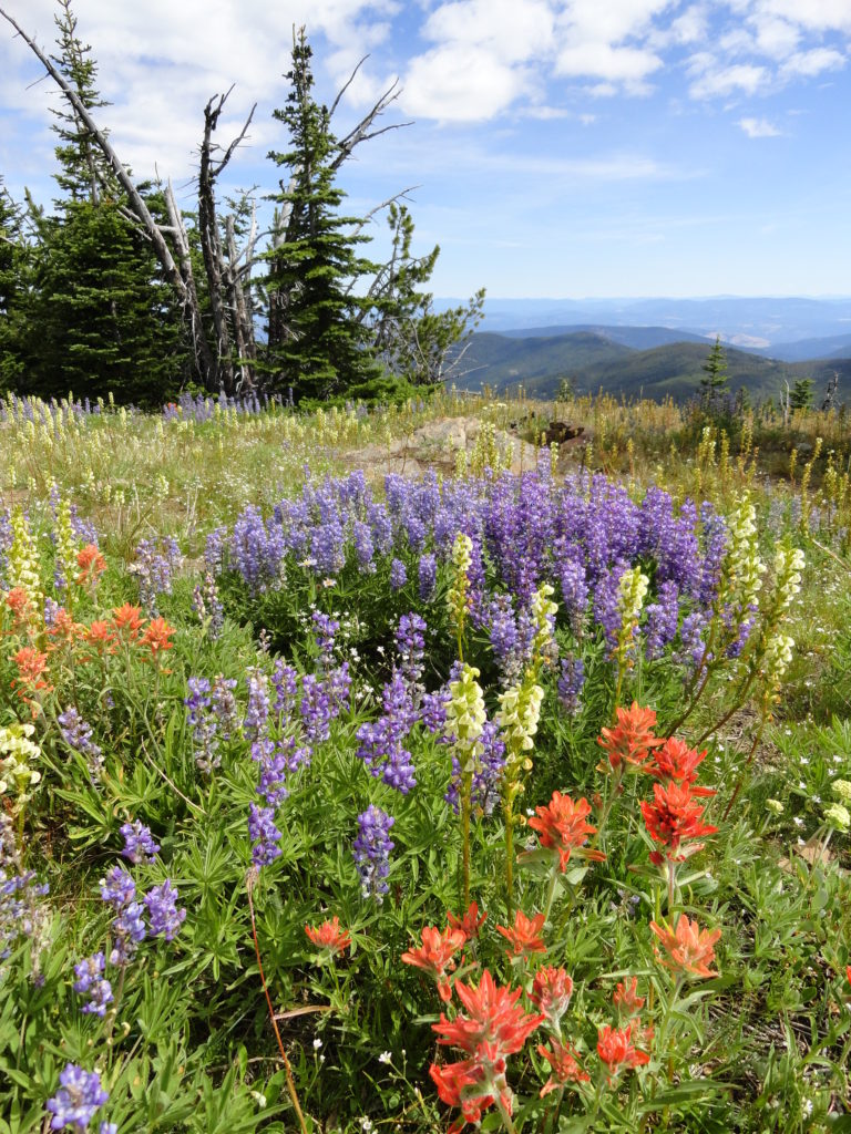
A couple of switchbacks ease the climb—then it’s one final push to the top. At 3.0 miles crest the broad butte. Within a swath of brilliant wildflowers flanked by whitebark pines and subalpine firs, a big cairn marks the mountain’s 7,140-foot highpoint. The site of a fire lookout, now all that remains is a rusted bed frame and some scattered debris.
The views however haven’t changed over the decades. They’re still grand. Look south along the rounded Kettle Crest to bulky peaks cloaked in golden lawns and emerald canopies. Peer northward and trace the lumpy spine of the Kettle Crest into British Columbia. Gaze west over sprawling rangelands in spacious valleys carved by retreating glaciers from another era. Then cast your eyes east to a sea of peaks rising progressively higher into Idaho. Not a bad visual payoff for such a non-taxing hike!
Copper Butte sits in the center of one of the largest unprotected roadless areas remaining within Eastern Washington. Conservationists are currently working on securing wilderness protection for this special mountain range—a biological bridge between the Cascades and the Rocky Mountains.
For more detailed information on this hike and many others within the Kettle River Range and throughout the Colville National Forest, pick up a copy of my (co-written with Rich Landers) Day Hiking Eastern Washington (Mountaineers Books)
For a great place to stay in the nearby historic gold mining town of Republic, check out the Northern Inn