White Pass–Sprawling meadows and stupendous views high on the Cascade Crest
Location: North Fork Sauk River
Land Agency: Mount Baker-Snoqualmie National Forest
Roundtrip: 19.4 miles
High Point: 5,850 feet
Elevation gain: 4,000 feet
Difficulty: strenuous
Green Trails Maps: Mountain Loop Highway 111SX
Contact: Darrington Ranger District: Mount Baker-Snoqualmie National Forest
Note: Northwest Forest Pass or Interagency Pass Required
Access: From Darrington, travel south on the Mountain Loop Highway for 16 miles turning left onto FR 49. Continue for 6.7 rough miles to a junction signed for Sloan Creek Trail. Turn left and reach trailhead in .1 mile.
Good to know: Dog-friendly, excellent backpacking, exceptional wildflowers, exceptional views, exceptional old-growth
This is a tough day hike, great weekend getaway, or a longer backpacking trip with lots of exploration possibilities. While throughout the summer the highcountry around White Pass explodes in a profusion of colors thanks to copious wildflowers—autumn offers a bug free and berry-plentiful trip.
Following the North Fork Sauk River Trail, immediately enter a forest of ancient and impressive cedars. The trail for the Red Mountain Lookout site soon takes off left. Continue straight soon entering the Glacier Peak Wilderness. The way is fairly gentle but you may find yourself frequently stumbling as your eyes are averted upward in admiration of the gargantuan trees surrounding you. Some of them measure over 9-feet in diameter. At 1.9 miles reach a junction with the challenging Pilot Ridge Trail heading right to a series of glorious high-country meadows. It’s a strenuous journey.
The North Fork Sauk Trail continues through yet more impressive groves of cedar, Douglas-fir and some silver fir to boot. Reach an excellent backcountry camping area near crashing Red Creek (el. 2,800 feet). Then continue deeper into the wilderness coming to the remains of the Mackinaw Shelter.
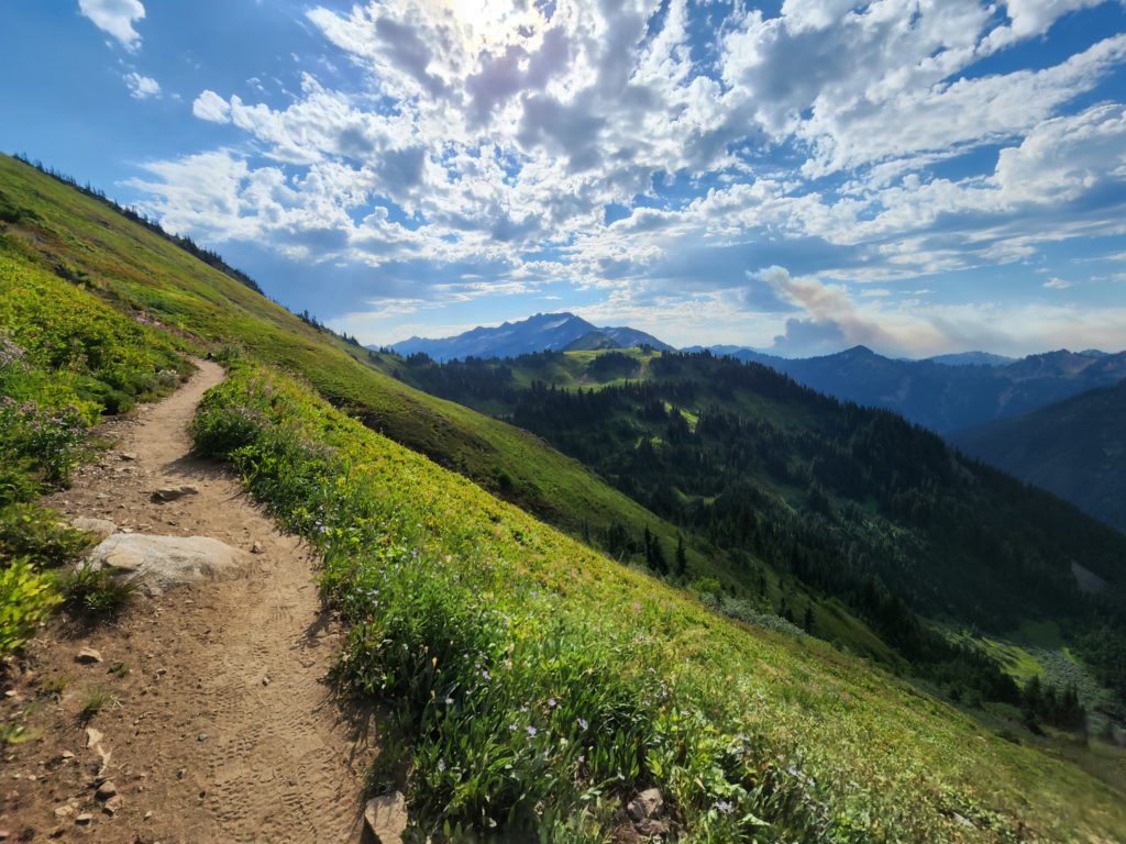
Gentle hiking is now a thing of the past as the trail begins a 3,000 foot ascent out of the valley. Utilizing a seemingly endless number of switchbacks, the trail angles upward through avalanche chutes before reaching high alpine meadows. Nearing the Cascade Crest, the grade eases. At about 9.0 miles, high on a windswept ridge, reach the Pacific Crest Trail. Now head right for 0.7 mile to lofty White Pass set between the meadow expanses of White Mountain and Indian Head Peak. Good but busy campsites are available just below the pass. Excellent high country roaming is available in every direction. The views are as expansive as the heights, especially to the south where rows upon rows of emerald ridges, rocky peaks, and serrated summits piercing puffy clouds fill the horizon.
For more detailed information on this destination and other great backpacking trips in Washington state, consult my best selling Backpacking Washington 2nd edition (The Mountaineers Books).