Twin Falls Lake–Hike to a secluded lake between two waterfalls
Quick Facts:
Location: Mountain Loop Highway near Granite Falls
Land Agency: Washington Department of Natural Resources
Roundtrip: 8.8 miles
Elevation gain: 1,200 feet
Green Trails Map: Mountain Loop HIghway 111SX
Contact: Northwest Region Ranger District WA DNR (360) 856-3500
Notes: Discover Pass required; trail beyond Ashland Lakes sees little maintenance, is extremely difficult and not recommended for children and novice hikers.
Access: From Granite Falls follow the Mountain Loop Highway east to the Verlot Visitors Center. Proceed for 4.6 more miles turning right onto FR 4020. Follow this gravel road for 2.7 miles bearing right onto FR 4021. Continue 1.4 miles, turning left onto Spur 016 reaching trailhead for Ashland Lakes in .2 mile.
Good to Know: old-growth; seclusion; spectacular waterfall, trail less taken
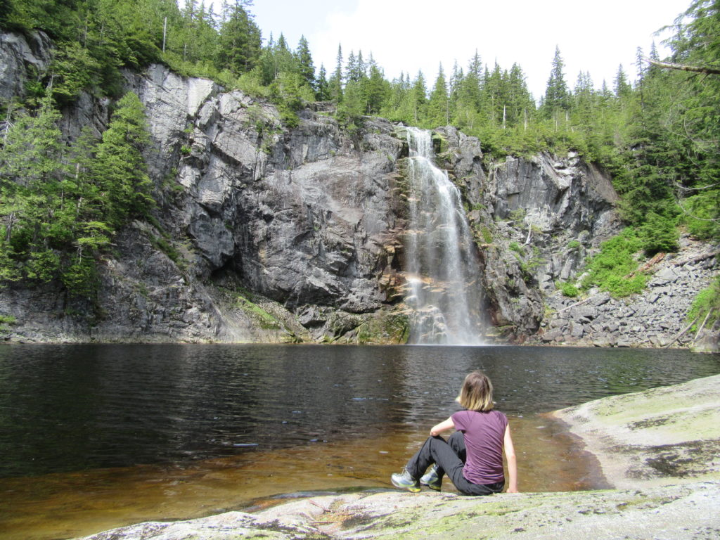
This is a rough and tumble hike to a little lake tucked between a stunning duo of crashing cascades in a remote corner of the 32,592-acre Morning Star Natural Resource Conservation Area (NRCA). Not recommended for children and those prone to twisting an ankle, the first couple of miles are easy-enough, following the way to the placid Ashland Lakes. But beyond, the trail drops steeply on a rocky and root-entangled path to little Twin Falls Lake situated right between careening cataracts.
Start on an old logging road turned easy-to-walk hiking trail traversing bogs and second growth forest. At 1.2 miles the old road transitions to real trail and enters old-growth forest. While the trail has been constructed well, care should be taken on all the planking which tends to get slippery. At 1.7 miles in a forest of huge cedars and hemlocks reach a junction. The trail left heads .1 mile to little Beaver Plant Lake, a sensitive wetland of sphagnum and peat bog. Continue straight cresting a 3,000-foot divide and reaching another junction. Left heads to Bald Mountain. Head right instead to Upper Ashland Lake and round the lake on nice boardwalks.
Continue to the lake’s outlet and follow another trail losing 200 feet to the lower Ashland Lake. Set in a rugged bowl, it’s more scenic than the upper lake. The trail continues, crossing Wilson Creek on a sturdy bridge, and then beginning a 400 foot descent in 1.7 miles. This section of trail is in tough shape with lots of roots, downed trees and collapsed bridges and boardwalks. Use extreme caution—especially in wet conditions. The increasing roar of the falls will let you know you are getting closer. The trail pops out of the forest at Twin Falls Lake, a little pool beneath the 125-foot upper falls. It’s a dramatic sight. The lower falls plummet 400 feet off a ledge below the lake. Unfortunately there is no clear safe view of it. Use extreme caution trying to catch a glimpse of it. Better yet, return to the little lake and relish in the beauty of the crashing upper falls.
For more detailed information on this hike and many others along the Mountain Loop Highway, pick up a copy of my best selling Day Hiking North Cascades 2nd edition